
What a day! We were up early to enable us to shower, eat breakfast, and break camp in time to get to Tex’s Riverways with our gear by 8:30 am. We ate our leftover quesadillas, warmed on the grill, and then took down our tents and stuffed them, our bedrolls, mattresses, clothes and toiletries into our dry bags. We’d already packed our food and cooking gear into coolers & food lockers.
Now we were ready to take all of our river gear to Tex’s. In a town full of rafting companies, scenic cruises, jeep safaris, and nearly any other sort of highly advertised high-adventure tack you can think of, "Tex's is notable in its understated presentation and peerless reputation." They don't do whitewater trips and cater to long-distance paddlers. Jess, who had made all the arrangements, had chosen well.
But, before we could head to Tex’s, we had to unload the 4-runner of most of its gear—stuff we were leaving behind and stuff Jess and Kim were to use after the canoe trip—in order to fit in the dry bags and food lockers etc. Even so, there was only enough room in the car for three plus the river gear, so I stayed at UTC with the unloaded pile. Jess returned to pick me up, and we loaded the stuff we were not taking back into the 4-runner and then parked it at the outfitter’s.
At Tex’s, we paid and signed all waivers and papers and met a couple and their son who were going to canoe and kayak (the son) the same stretch as we.
Each party was supplied with a square metal toilet with a firm-fitting lid, carrying handles, and a detachable seat (in a mesh bag), which fit snugly on top. Really a lot less horrible than it sounds. Then it was time for the “potty training,” given by Ken who would transport us to the put-in. Basically it went like this:
- This backcountry toilet is called a Groover because the first ones were lidless army ammo boxes that left grooves in ones bottom
- Do not lose the lid. It will cost you $80. Wind and water have carried lids away before, so make sure it is strapped to the Groover.
- Do not forget the Groover itself. It will cost $600 to replace.
- Pull the little vent wire to release gases before unscrewing the gasketed lid—this to prevent the contents from exploding in one’s face.
- Keep the gasket clean so the lid will seal tightly. The chemicals in the Groover will break down the waste and odor should not be a problem . . . unless one does not seal the lid properly.
- Pee in the river, as far out as possible; poop in the Groover.
- Keep the fire in the issued fire pan.
- Before leaving camp, pour water into the firepan, strain off any sizable burned wood that floats, and place it in a bag to be used on the next night’s fire.
- Throw the remaining ashes into the river . . . as far out as possible.
- Burn only dead wood. Do not cut any live wood or limbs. (There was oodles of driftwood to burn.)
- Sweep the area around the fire to leave no ashes or trace.
- Camp anywhere along the river, though camping on the sandbars is recommended. Water will wash over them cleaning them and leaving no trace.
- If camped in or near a wash, place the tent high to avoid being swept into the river by a flash flood. . . common in these areas.
- Do not leave bits of food or trash about. Everything that goes in must come out. Do not feed the ravens. Beware of their stealing your food.
- Avoid stepping on cryptobiotic earth.
Entrada sandstone
Navajo sandstone
kayenta formation
wingate sandstone
chinle formation
moenkopi formation
Though we had seen it before, Ken stopped once to point out examples of cryptobiotic soil also.
 |
| Road to Mineral Canyon's edge from the back seat of the van |
 |
| Looking from the canyon rim down to the Green River at Mineral Canyon Landing |
 |
| Peter takes a photo of his three female companions |
 |
| Kim takes a photo of Peter, me, and Jess on the Mineral Bottom canyon rim |
The last mile dropped down the most spectacularly scary road I've ever been on, switchbacking back and forth in at least a dozen tight, hairpin turns down the nearly vertical side of the canyon. A pair of twisted metal sculptures—formerly cars—resting amidst and beneath boulders a hundred feet down from the road was a vivid warning of what happens if you get too close to the crumbling edge. I was very glad I wasn't driving an old van and large trailer down this road, but, in truth, being a passenger wasn't much better! Of course, Ken drives this road practically every day, and handled it with ease. He even told us of navigating it the previous week in snow and ice! He also, bless his black soul, took his hands off the wheel twice (ha, ha) in a roller coaster whoop to make it scarier.
 |
| Look at all the slides, and particularly the one beside the front cyclist that has almost taken the road with it. Years after going on this trip, I read an article and saw pix of a giant slide that wiped clean the canyonside and did take this road. |
We arrived at the Mineral Bottom staging area and set about unloading, assembling, and then loading the canoes with our gear. This was a process that we would get much better at over the next few days as we learned what fit where. First, Ken showed us how to transform our two canoes into one “catamaran” called a T-Cat. (My suggestion for a name was “cat-a-canoe.”) This was a wonderful arrangement that made the canoes very stable (we could even stand up to paddle when we grew weary of sitting) and enabled us to pack a lot of gear on the platform between the two canoes. The T-cat was also surprisingly easy to maneuver and paddle. We grew to love our T-cat and decided that it was the best way for three or four persons to paddle the river together.
Two rangers met us at the put-in to check our backcountry permits and to tell us again some of the rules of backcountry camping. After all this, we asked Ken to take our photo, and then we were off, paddling down the murky greenish river with cliffs and formations towering on either side.
Two rangers met us at the put-in to check our backcountry permits and to tell us again some of the rules of backcountry camping. After all this, we asked Ken to take our photo, and then we were off, paddling down the murky greenish river with cliffs and formations towering on either side.
 |
| The van, Ken (right) and the mother and son who were going to canoe and kayak the river |
 |
| Stashing all of our gear in the T-cat (two canoes with a platform between them); I'm wearing my bicycle gloves to paddle |
 |
| Finally we're stashed, Ken takes our photo, and we're off |
It was 11 o’clock when we finally started off from Mineral Bottom, 53 miles from the confluence with the Colorado River. We had four days to paddle approximately 57 miles. Upon getting to the confluence, we could paddle down the Colorado for five miles before finding a take-out site above Cataract Canyon—a whitewater section of the Colorado. We were instructed to have our canoes and gear out, clean, and ready for an airboat pickup at 11 am. The air boat would take us the 60-some odd miles up the Colorado and back to Moab.
Jess and Peter rode rear and steered; Kim and I rode front and were the motor. So situated, we birded (mallards, cliff swallows, Canada geese, ravens, quite a few spotted towhees, eastern phoebe, small flock [6] cinnamon teal, great blue heron, turkey vultures) and oohed and ahhed our way down the river. Almost immediately we saw a number of river otter slides but no otters.
At about 1:30 pm, we stopped at a large white sandbar in the middle of the river for lunch. Jess and Kim set up the portable table, and we ate (cannot now remember what) and lazed about for a bit, giving our “canoe muscles” a rest. It was cloudy and windy so we had quite a time ensuring that the table and food did not blow away. As the afternoon wore on we saw rain in the distant clouds, but none fell on us.
 |
| Kim's panoramic photo of Jess and Peter |
 |
| Jess happy to finally be on the river |
 |
| Not 100 feet from the put-in we broke out the beer |
 |
| What I called the clock tower but the others called something less dignified |
 |
| Ravens and something else on a cliff ledge |
 |
| The calm water at Mineral Bottom where we put in |
 |
| A bowl canyon |
 |
| So this is how the arches form |
 |
| The White Rim 4-WD and MTB trail runs along the top of the canyon; Jessica rode it on her MTB with a small group in 2012 |
 |
| Peter naps while Jess struggles to set up an umbrella to shade our lunch goodies and protect them from the wind |

While we were eating, the canoe/kayak family that had staged with us, passed by . . . or tried to. The boy in the kayak got hung up on a sandbar and had to lift himself and the kayak several yards with his arms and hands until he hit deeper water.
We, too, got hung up a couple of times and had to get out to walk the t-cat to deeper water. Yiii! The water was COLD, and the river deeply silty in places near the shore and sandbars, the silky mud dragging one’s shoes off or causing us to sink to near knee depth! However, we got much better at “reading” the river as the day and days passed, so learned to avoid submerged sandbars and what we called “soft” landings.
We, too, got hung up a couple of times and had to get out to walk the t-cat to deeper water. Yiii! The water was COLD, and the river deeply silty in places near the shore and sandbars, the silky mud dragging one’s shoes off or causing us to sink to near knee depth! However, we got much better at “reading” the river as the day and days passed, so learned to avoid submerged sandbars and what we called “soft” landings.
 |
| We soon learned to avoid this kind of saturated sand/silt as it was a shoe-sucker and difficult to wash off |
At about 3 o’clock we began to look for a good campsite. Another outfitter had put several rafts and canoes in the river that day so each time we saw the “perfect” spot, someone was already there . . . including our canoe/kayak family at one place. They later continued past us so we had to dodge them twice. It was getting late, and we were getting tired. Our mantra became “just around the next bend.” We were all unable to tell exactly where we were on the river. Though we had an excellent map, the landmarks didn’t seem to match up. Jess was sure we’d paddled only about 6 miles, but that was fine with us, we had four days to paddle 57 miles at most, 52 if we stopped at the Confluence.
 |
| Pulling in to our first campsite |
 |
| Jess wrestling with a drybag; now one can see why the river is named the Green River |
Finally at about 5:30 or 6, we spotted a sandbar island close to some tall cliffs. It was not a “solid” landing site, so we slogged through a couple of feet of pull-the-shoes-off silt, but managed to haul out and anchor the T-cat. We checked the map and determined that we had paddled not 6 but a full 16 miles, and were camped below Tower Park across from Potato Bottom at mile 37 on our map.
We were all pretty exhausted what with all the excitement of prep time and the miles we’d paddled, but we unloaded the T-cat and found good places for our tents. We were hurrying as it appeared that the rain would catch us. Peter found a board and scraped out a flat, soft tent site at the top of the sand dune. Kim & Jess and I put our tents on the harder sand at the bottom of the dune.
We were all pretty exhausted what with all the excitement of prep time and the miles we’d paddled, but we unloaded the T-cat and found good places for our tents. We were hurrying as it appeared that the rain would catch us. Peter found a board and scraped out a flat, soft tent site at the top of the sand dune. Kim & Jess and I put our tents on the harder sand at the bottom of the dune.

 |
| Peter retreats to his tent after set up |
We set up Groover in a private place on the cliff side of the island. This side of the island had very shallow water running along it. In fact in one place the water had dried out leaving a muddy bar.
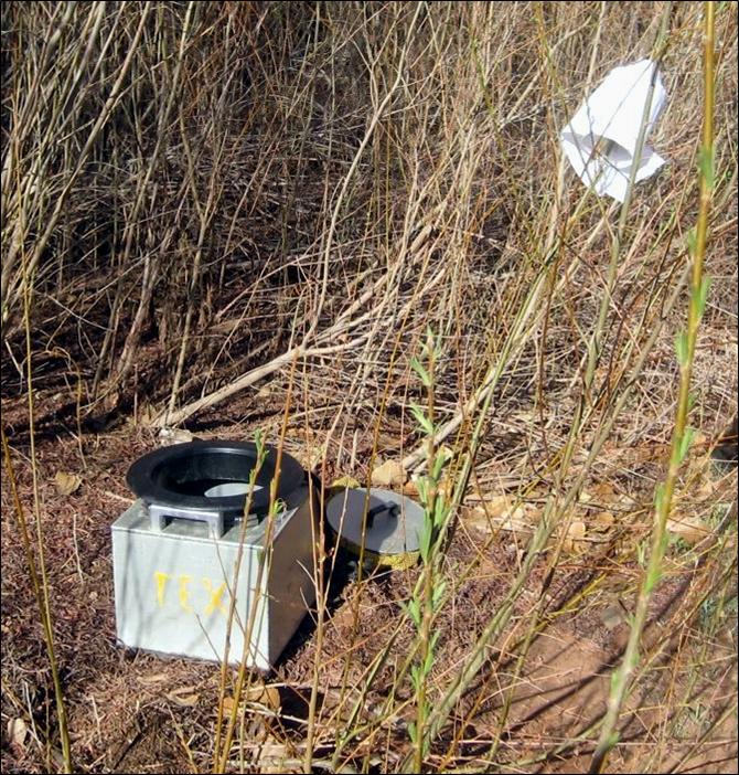 |
| Groover set up in a young willow grove |
In no time Peter had a fire going in the fire pan, and Kim had cooked up a delicious meal, served with hor d’ouvres and wine, no less. If I remember correctly, this meal was flank steak, real mashed potatoes, veggie, avocado and tomato tossed salad. Very delicious and certainly not typical camp fare! We cut willow marshmallow sticks and had roasted marshmallows for desert. Carried the sticks with us for the whole trip.

 |
| The setting sun illuminating the tower after which Tower Park Camp is named |
 |
| Peter gathering driftwood for our camp fire |
 |
| Jess and Kim setting up the kitchen |

I tried walking through the shallow water to the trees where the herons were, but could not get through the tangle of undergrowth and climb to the bottom of the cliffs. I saw many browsed willow twigs, bitten cleanly off about a foot from the ground. I also found a place next to the cliffs where some animals obviously bedded down for the night, as well as mountain sheep, deer, and raccoon tracks in the river mud. Also, one set of big cat tracks. My tracks, for the most part, looked like Bigfoot because the silty sticky mud stuck to my feet and between my toes. I carried around about a pound on each foot. It was nearly impossible to get the silty mud off our shoes and feet.

That night it blew and rained. And, lo, that night I had to get up to visit Groover! I waited until I was fit to burst and then made my way to Groover during a break in the rain. The moon dimly illuminated the cliffs and sandbar. It was actually a peaceful setting, and I speculated about sleeping ravens. I was hoping a mountain sheep or deer would come down for a drink, but saw naught.
No comments:
Post a Comment